
Publishing Scholarly Archaeology since 1997
Publishing Scholarly Archaeology since 1997
Log in | My Account | Basket Twitter Facebook LinkedIn
Advanced Search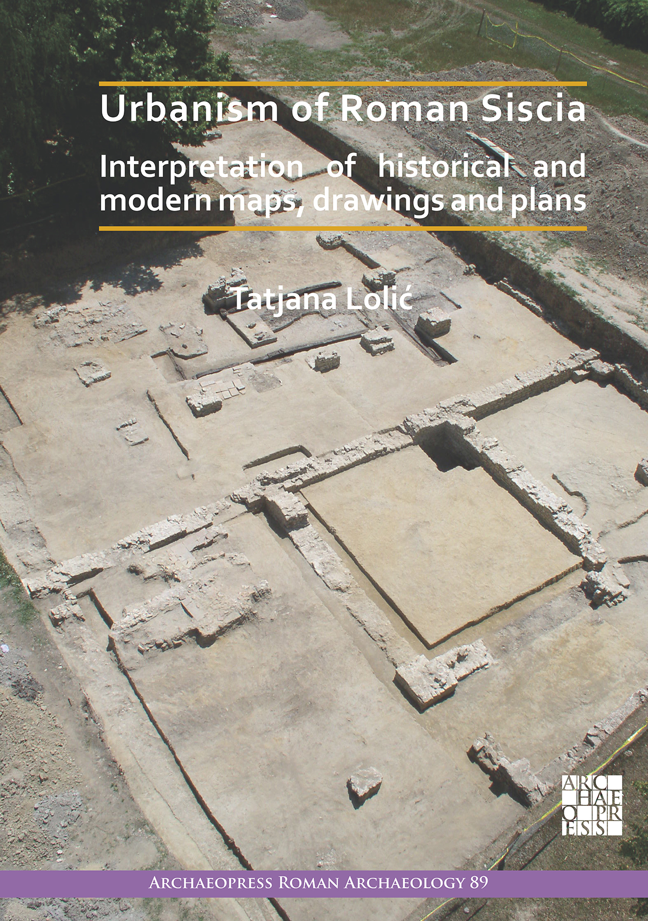
Download Sample PDF
H 290 x W 205 mm
216 pages
263 figures, 12 plans, 1 map (colour throughout)
Published Apr 2022
ISBN
Paperback: 9781789696233
Digital: 9781789696240
Keywords
Croatia; cartography; architecture; residential; city development; Roman; street networks; water supply
Related titles
Archaeopress Roman Archaeology 89
Urbanism of Roman Siscia
Interpretation of Historical and Modern Maps, Drawings and Plans

Paperback
£40.00
Includes PDF
PDF eBook
(personal use)
£16.00
PDF eBook
(institutional use)
£40.00
 Add to wishlist
By processing data from every archaeological excavation, and analysis and interpretation of all available historical and modern documents, this volume presents a thorough overview of the structure of Roman Siscia (modern day Sisak, Croatia) and provides a comprehensive starting point for all future work on the Roman city.
Contents
Foreword ;
1. Introduction ;
2. Location and urban topography of siscia according to literary sources ;
3. History of the archaeological research ;
3.1. Excavations in the 19th and the first half of the 20th century ;
3.2. Archaeological research in the period 1945–1979 ;
3.3. Archaeological research in the period 1980–2020 ;
3.4. Similar works (syntheses) ;
4. Cartographic sources ;
4.1. Classical and medieval cartography featuring symbolical depictions of Siscia ;
4.2. Cartography of Luigi Ferdinando Marsigli ;
4.3. Cartography in the 18th to 20th centuries ;
5. Archaeological interpretation ;
5.1. Block 1: Bana Jelacica Sq.–V. Nazora Promenade–S. S. Kranjcevica St ;
5.2. Block 2: S. S. Kranjcevica St–A. i S. Radica St–I. Kukuljevica Sakcinskog St– Rimska St–Šetnica ;
5.3. Block 3: A. i S. Radica St–S. S. Kranjcevica St – I. Kukuljevica Sakcinskog St-A. Starcevica St ;
5.4. Block 4: A. i S. Radica St–A. Starcevica St–I. Kukuljevica Sakcinskog St–F. Lovrica St ;
5.5. Block 5: I. Kukuljevica Sakcinskog St–A. i S. Radica St–Matije Gupca St–Ljudevita Posavskog Sq ;
5.6. Block 6: A. i S. Radica St–I. Kukuljevica Sakcinskog St–A. Starcevica St–Ljudevita Posavskog Sq.–Matije Gupca St ;
5.7. Block 7: A Starcevica St– I. Kukuljevica Sakcinskog St– Matije Gupca St–F. Lovrica St ;
5.8. Block 8: Rimska St–Matije Gupca St–Ljudevita Posavskog Sq.–A. i S. Radica St–Frankopanska St ;
5.9. Block 9: A. i S. Radica St–Ljudevita Posavskog Sq.–A. Starcevica St–Matije Gupca St– Frankopanska St ;
5.10. Block 10: A. Starcevica St–Frankopanska St–Matije Gupca St– F. Lovrica St ;
5.11. Block 11: Frankopanska St–Rimska St–N. Šipuša St–Biskupa Kvirina St ;
5.12. Block 12: Kralja Zvonimira St–N. Šipuša St–F. Hefelea St–Biskupa Kvirina St–the Segestica factory premises ;
5.13. Block 13: the Kupa River from the Odra Bridge to the Old Bridge ;
5.14. Block 14: Pogorelec (the right bank of the Kupa)–the Old Bridge–J. J. Strossmayera St–the New Bridge ;
5.15. Block 15: Sisak Novi, J. J. Strossmayera St–A. Cesarca St–I. Gundulica St ;
5.16. Block 16: Pogorelec, the west part ;
6. Conclusion ;
6.1. Modern context of the site, the state of research and documentation ;
6.2. Early development of the urban area of Siscia ;
6.3. Developed town matrix of the Flavian period ;
6.4. Development of administrative and public functions during Antonine dynasty ;
6.5. The status of Siscia and major construction projects in the period of Severan dynasty ;
6.6. The capital of the Roman province of Pannonia Savia ;
Literary sources ;
Bibliography
About the Author
Tatjana Lolic is Head of Sector in the Croatian Ministry of Culture. She studied Archaeology and History of Art and received her doctoral degree in Archaeology from the University of Zagreb; She undertook specialist study in Architectural Conservation at ICCROM, Rome, Italy, and has the title of docent at the University of Zagreb where she has been guest lecturer for ten years. She is experienced in the coordination and supervision of archaeological excavations and conservation projects in Croatia and has published extensively on Roman Siscia.Reviews
'T. Lolic’s book can be considered a fundamental work for the study of Pannonian cities. The author presents the urban structure of Siscia, its layout and the buildings investigating so far, based on the completeness of the data. We can only praise the research that has been carried out in the difficult conditions of urban excavation, since the modern city was built on the site of the Roman colonia. The work presents important stages of the urban development of Siscia well documented, with a series of colour photographs.' – Dénes Gabler (2023): Acta Archaeologica Academiae Scientiarum Hungaricae 74

Archaeopress Publishing Ltd
First and Second Floor
13-14 Market Square
Bicester
Oxfordshire OX26 6AD
United Kingdom
Tel +44 (0) 1865 311914 | fax +44 (0) 1865 512231 | email info@archaeopress.com
